Silver Glen Springs
Why We Love This Spring
When I go to a Florida spring with my family or friends, the first thing we do after parking the car is hurry down and check out the spring. Everything else – putting on bathing suits or gathering snorkeling gear – just has to wait until we have the chance to soak up its beauty.
The appreciation of some things requires a certain familiarity, or perhaps, even education. For instance, the subtle beauty of Florida landscapes is often lost on newcomers. More than once when I have shown an out-of-state guest a fine example of, say, south Florida pine savannah, or even the famed Everglades, they are moved to comment that “It sure is flat”. However, Florida springs never elicit so tepid a response. Their striking beauty is lost on no one.
Silver Glen Springs is no exception, and in the opinion of many, it is among the most beautiful of Florida’s blue gems. When I was asked to moderate a spring site, I knew I had lucked out in getting Silver Glen. Beautiful, popular, and with a fascinating natural and cultural history, I knew it would be easy to write about this spring.
Silver Glens’ attraction is in no small part due to its exceptionally clear water and beautiful setting in the Ocala National Forest. Unlike some Florida springs, the unparalleled clarity of the water at this spring can always be counted on. Most of Silver Glen’s watershed lies within the ancient sand dunes of the National Forest, where swamps are uncommon and rainwater seeping into the pure sand is untainted by tannin-stained runoff. Furthermore, the nearby St. Johns River is well-behaved, never rising high enough to inundate the spring run, much less the spring itself.
Silver Glen’s surroundings are themselves not without interest. To the west of the spring lies a vast and ancient dune field. The sandy hills of often pure white sand are covered by the dry sand pine scrub ecosystem. Endemic to Florida, this habitat is chock full of unique plants and animals. The Ocala Forest harbors the largest expanse of this ecosystem and is known, rightly enough, as the Big Scrub.
Silver Glen lies at the eastern toe of these dry hills where the dunes drop over seventy feet in elevation (a big deal in Florida) and, in a study of contrast, the dry scrub gives way to rich moist lowland forest. Numerous cabbage palms give these low woods a decidedly tropical flair.
Shell mounds and numerous artifact sites near the spring and along the run attest to a long and ancient occupation by Florida’s aboriginal inhabitants, spanning at least 10,000 years and representing most of the known cultural periods in northeast Florida. This spring has been popular for a long time.

Women snorkeling underwater in clear blue spring water with sunlight above Silver Glen
Photo by Mark Long
Back in the low woods sand boil springs roil silently at the head of a clear run, mimicking the famous mud-pot springs of Yellowstone, but without the gaudy colors – just the pure white of quartz sand, the same sand found on Florida beaches, the dust of the eroding Appalachians. Indeed, long ago, the Atlantic coast was located right here at Silver Glen.
To the east, beyond the mouth of the spring run, is one of Florida’s greatest vistas, a lake so large one can barely see across it. This is Lake George, the largest of a series of lakes connected by the St. Johns River, and the second largest lake in Florida. Here, far from the mouth of the St. Johns, it is still tidally influenced, and several of the springs flowing into the lake, including Silver Glen, are somewhat salty. The mild salinity is favorable to a number of marine fish and invertebrates, including blue crabs, jack cravelle, and Atlantic sting rays. It is always an unforgettable snorkeling experience to see these salt water animals mingling with the familiar fresh water fish in the clear waters of the spring.
I believe there are few places where a day can be better spent than Silver Glen Springs. There is much to see and do. And I am surprised the Spaniards, in their search for the fabled Fountain of Youth, did not stop right here. I know I always feel clean, refreshed, and yes, even younger, after each visit to this fine spring.
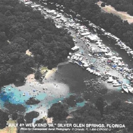
However, Silver Glen is not without its problems, most of them resulting from its own popularity. The lush beds of eelgrass and other native vegetation that once graced the spring and run have been seriously damaged by boats and bathers, opening the door to invasive exotics. And a recent and poorly understood runaway growth of algae further threatens the health and beauty of the spring.
Nonetheless, the visitors still come. And Silver Glen strikes them as so extraordinary that they are usually full of questions for anyone who will take the time to talk to them. Among other things, they want to know: Where does so much water come from? Why is it so clear? Is there a cave down there? What about the sting rays, what are they doing here? Will they hurt me? Are there sharks here too? Are those Indian mounds?
I hope this site will be of use to all those who wonder about such things. The site will address the natural and cultural history, science, artistic resources and challenges to Silver Glen Springs. There is now a wealth of resources dealing with springs on the internet, and the reader is encouraged to explore further via the links and references provided.
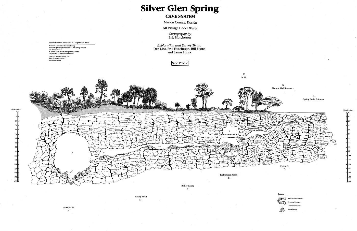
Silver Glen Spring Cave System Map
Cartography by: Eric Hutcheson
-
This diagram shows a side profile of the Silver Glen Spring cave system in Marion County, Florida, with all passages underwater. The illustration depicts a forested surface landscape above layered limestone formations, and an extensive network of submerged cave passages below ground.
Depth scales labeled “depth in feet” appear on both the left and right sides, ranging from 0 to 160 feet below the surface.
The upper portion of the diagram labels surface features and entrances, including: C – Lee Pit, B – Natural Well Entrance, and A – Spring Basin Entrance.
Below the surface, the cave system includes labeled chambers and passage areas from right to left: D – Phirst Pit, E – Earthquake Room, F – Boiler Room, G – Rocky Road, and H – Awesome Pit. These labels correspond to specific locations within the illustrated cave network.
The diagram shows a combination of horizontal passageways and vertical shafts connecting different chambers, illustrating how the cave system extends beneath the landscape.
A legend in the lower right corner explains symbols used in the map: rock shapes indicate limestone formations, intersecting diagonal lines represent crossing passages, arrows show the direction of water flow, and clusters of rocks indicate breakdown areas.
The map title reads “Silver Glen Spring Cave System, Marion County, Florida,” with additional notes stating that all passages are underwater. Cartography is credited to Eric Hutcheson, with exploration and survey conducted by Dan Lins, Eric Hutcheson, Bill Foote, and Lamar Hires.
Additional small text notes that the survey was produced in cooperation with multiple organizations, including the National Association for Cave Diving, the U.S. Forest Service, the St. Johns River Water Management District, and other supporting groups.
Learn more about Silver Glen Springs
-
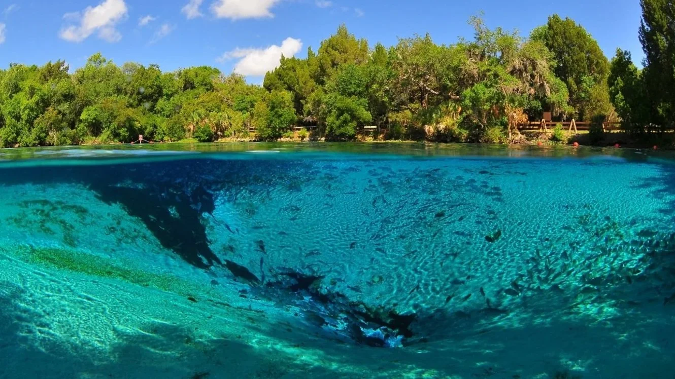
![Large group of fish swimming inside a spring vent or cave opening]()
Know Your Springshed
Silver Glen Springs is fed by local rainfall that seeps through sand and limestone within its springshed. Protecting the spring means understanding and caring for the land that drains into it.
-
![Aerial view of Silver Glen Springs with many boats gathered along the shoreline]()
Health and Science
Silver Glen Springs faces growing pressure from heavy recreation and ecological imbalance. Ongoing research and management are essential to restoring vegetation and protecting the spring’s long-term health.
-
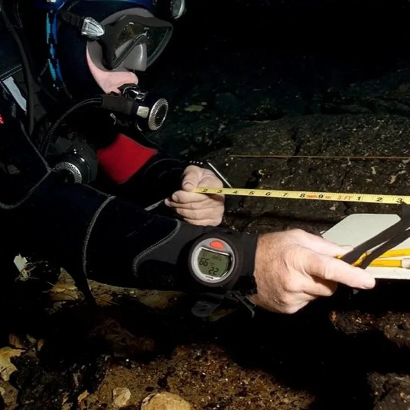
![Scuba diver underwater measuring or recording data on the spring floor]()
Caring for Your Spring
Protect Silver Glen by respecting aquatic plants, wildlife, and fellow visitors while at the spring. At home, conserve water, limit fertilizer use, and support policies that safeguard the springshed.
-
![Vintage illustration of a woman with children emerging from water holding a basket]()
History
Silver Glen Springs has drawn people for over 10,000 years, leaving traces of ancient shell mounds. From early explorers to present day cave divers, its story continues above and below the water.
-
![Man working at a desk drawing or mapping underwater cave or spring formations]()
Art, Literature & Film
Silver Glen has a long history of inspiring artists, writers, and filmmakers for generations. Its clear waters and hidden aquifer continue to inspire and shape story, image, and imagination across time.
-
![Moderator Tom Morris in scuba gear floating at the water’s surface wearing mask and gear]()
About Your Moderator
Tom Morris is a lifelong Florida scuba diver and biologist devoted to springs and aquifer caves. For decades, he has explored, studied, and worked to protect these magnificent waters.